ASSESSMENT OF THE IMPACT OF THE WIND PARK ON THE LANDSCAPE
The latest generation of wind power plants form vertical dominants in the landscape of the immediate surroundings. The impact on the landscape, especially its visual aspects, is one of the most important issues assessed during the planning stage of wind farms. Several parameters of wind power plants and wind parks affect the visual image of the landscape, including the height of the wind power plant throne, rotor size, the ratio of tower height and rotor size, the total number of wind power plants, color and material, access roads and squares, and power grid transmission lines.
When assessing the impact of wind power plants or wind farms on the landscape, it must be assumed that power plants can be visually perceived in relation to the overall landscape at a distance of up to 15 km. The visual impact of wind farms decreases as the distance of visual perception increases.
Assessing the visual impact on the landscape is largely subjective. It is possible to maximally reduce the subjective aspect in the evaluation of visual effects by using a unified methodological approach and the application of modern methods in the process of visual effects evaluation. In order to evaluate the impact of the wind park on the landscape, we use spatial modeling solutions, which help to quantitatively and qualitatively evaluate landscape changes both on a larger scale and from local points of view.
SURVEY OF THE TERRITORY IN NATURE
We survey the territory, surrounding settlements, the most important viewpoints, cultural monuments, culturally significant objects and tourist objects in the immediate vicinity. We do photofixation.
ANALYSIS OF TERRITORIAL DEVELOPMENT PLANNING DOCUMENTS, GUIDELINES AND INTERNATIONAL EXPERIENCE
When carrying out the assessment, the restrictions set at the national and local government level in relation to landscape protection and the conditions regarding landscape protection at the site of the intended activity should be taken into account in accordance with the current regulatory enactments. We are studying territory development planning
high-value landscape areas and popular tourist areas in the vicinity of the planned wind farm, defined in the documents. We evaluate the guidelines prepared by the state institutions in the planning and evaluation of wind farms. We take over the best
examples of international experience in the evaluation of the wind park’s impact on the landscape.
VISIBILITY MODEL
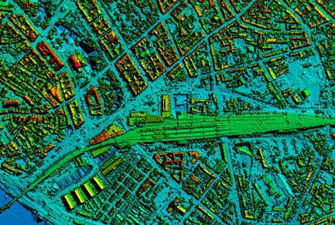
We are developing a wind park or solar park visibility model to identify potentially affected areas. To prepare the model, we use spatial data on the location of wind power plants and their technical characteristics, data on the terrain of the researched area, as well as data on the height of vegetation and the volume of existing buildings. The development of the model makes it possible to identify the areas from which the wind power plant will be fully or partially visible, taking into account the terrain, surface vegetation and construction, as well as to quantitatively assess the importance of changes in the landscape from certain viewpoints.
The visibility analysis uses the basic data of the digital height model obtained by the aerial laser scanning method, which is an accurate and efficient method of obtaining data on the Earth’s surface with LiDAR (Light Detection And Ranging) technology. The basic data source of the digital elevation model is the files of the Geospatial Information Agency of Latvia, which are freely available. From the basic data of the digital height model, a digital Earth surface model or DSM (Digital Surface Model) has been created, which includes the tops of vegetation, buildings and other objects. DSM updated using data from the State Forest Service. Using the geospatial analysis tool “gdal_viewshed”, the areas from which prospective wind power plants would be visible at human eye level have been determined.
Based on the data of the visibility model, it is possible to assess whether there are scenically valuable objects in the potentially affected territory, as well as whether the potentially affected territory does not affect areas where high-value landscape spaces have been determined at the national, regional or municipal level.
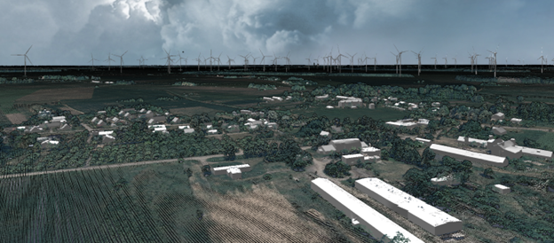
CREATION OF VISUALS
Before the detailed design and construction of the wind farm, it is essential to evaluate how the designed wind power plants will be visible from populated areas and important objects. Supplementing the visibility model with information on cultural, natural and touristic objects, residential and public areas, possible particularly sensitive areas are identified. We analyze each of them separately, assessing the significance of the wind park’s impact. We are preparing images in which the original landscape is supplemented with the planned wind power plants.
The visual impact of wind farms depends on the location of individual power plants, their arrangement in relation to other landscape elements and landscape features, the total number of power plants and the type of grouping. By analyzing sensitive areas, it is possible to find solutions to reduce the impact of wind power plants on the landscape by changing their location or mutual arrangement.
We also evaluate the possible overall impact of various objects on the landscape. It is significant if it is planned to implement more than one wind energy project at the same time
Reviews
There are no reviews yet.